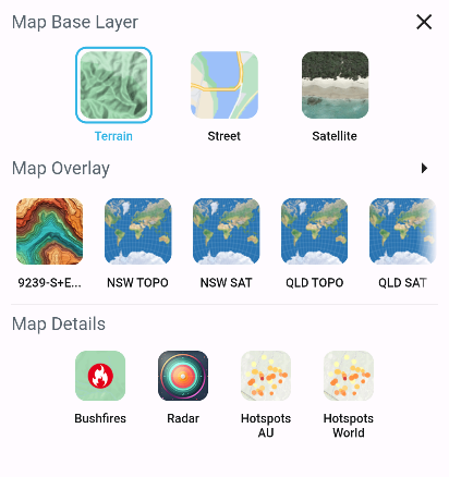
Layers Menu
The Layers Menu in Ember Map is accessible from the Map Screen, offering a plethora of options to augment your situational awareness in fireground scenarios.

Map Base Layers
Ember Map furnishes three primary base maps: Terrain, Street, and Satellite. These base layers provide a fundamental visual backdrop to help users orient themselves geographically.
Map Overlays
Map Overlays enrich the map with additional tile map services or imported GeoPDF maps incorporated within the app. Among these overlays are Topographic and Satellite imagery procured from various state spatial services globally.
For instance:
- Selecting NSW TOPO unveils rural property names of homesteads along with asset locations.
- NSW SAT grants access to often higher-resolution satellite imagery covering the state of New South Wales.
Map Details
Map Details layer additional information atop your base maps and map overlays, encapsulating:
- Bushfires
- Markers and polygons indicating bushfires in Australia (AUS), the United States (US), and Canada (CAN) are supported. Clicking on a bushfire marker reveals further information about the incident.
- Hotspots
- Benefit from near real-time satellite hotspot detection displayed worldwide. Hotspots on the map indicate areas of high temperature which could be useful in finding reported incidents or possible ignition points from lightning strikes.
For additional support regarding NSW RFS Map Details and features, click here.